InfraWorks 2018.2 Brings User-Friendly Updates
Michael Molitch-Hou posted on March 19, 2018 | | 161 views
At the close of 2017, Autodesk announced an update to InfraWorks, the company’s infrastructure visualization tool. Now, the update is available to all InfraWorks users, allowing everyone to enjoy the new features outlined in this article.
Road modeling is streamlined within the new InfraWorks update. Menus, including the assembly picker, have been consolidated, and geometric data, such as tangent length, can be directly entered during the modeling process. Road layouts can be defined either using elements, placing a combination of tangents and curves, or using the PI-based method. Tips and warnings that appear at the bottom of the canvas are now easier to distinguish, as well.
Quantity analysis is now an expanded feature within InfraWorks. For instance, users are now able to define not only up to four ranges for drainage quantities but also material quantities for utilities, including pipelines and pipeline connectors, part of the software. Model features that are included in a quantities analysis—parts of a road, for example—will be highlighted to help users better visualize what is being analyzed. Quantities data can now be exported to a CSV file.

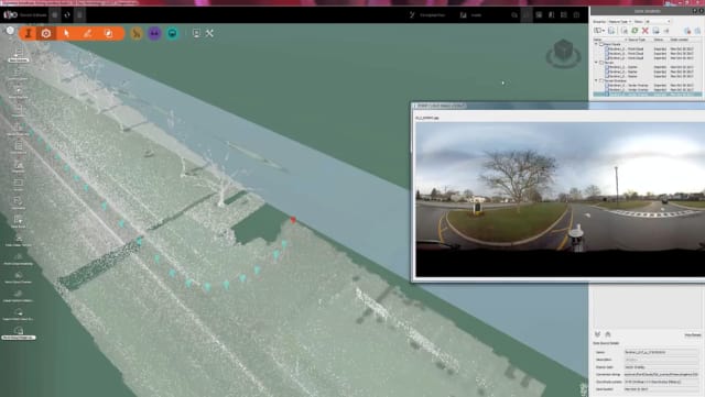
Images can be taken from point cloud scans via a Point Cloud Image Lookup tool. (Image courtesy of Autodesk.)
Reality capture tools have been improved in the latest InfraWorks update. Vertices…

