Airborne Light Scan Unlocks Secrets of Maya Ruins
Emily Pollock posted on October 08, 2018 |

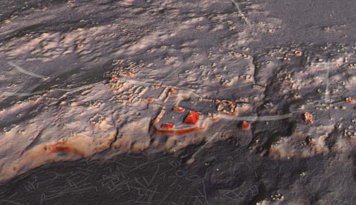
A representation of the Naachtun, Petén archaeological site, created by LiDAR data. (Image courtesy of Auld-Thomas and M. A. Canuto, 2018.)
Airborne laser scanning is often used to prepare for new construction, but a recent study in Guatemala used the technology to understand some very, very old construction.
LiDAR is an active remote sensing technology that uses laser pulses to create a 3D map of ground land cover and ground surface in three-dimensional space. Two years ago, Guatemala’s Pacunam LiDAR Initiative (PLI) embarked on the largest-ever survey of the Maya Biosphere Reserve, collecting data on 2144 km2(827.8mi2) of ground. The researchers hoped that their survey would provide more data on the ruins of an old Maya lowland settlement located on the territory.
A LiDAR system collects data by sending quick light pulses at the ground, and using a sensor to measure pulse return. Using differences in return time and return wavelength, scientists can map out 3D images of the underlying terrain. In this case, the PLI used a Titan MultiWave multichannel, multispectral, narrow-pulse width LiDAR system. According to parent company Teledyne Optech, it’s the first airborne LiDAR sensor to capture data in multiple spectra. Its standard configuration measures visible spectrum RGB light, near-infrared (NIR) light, and intermediate infrared radiation, which…

