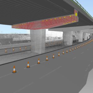
Traditional surveying? Drone photos? Sonar? LIDAR? How you get your point cloud data doesn’t particularly matter. The question is: what comes next? How do you go from point cloud to 3D model?
Brian Flaherty and Michael Harvey tackle this challenge head-on in their AU 2017 class and show that complex conditions are nothing to fear. Combining AutoCAD Civil 3D with Leica CloudWorx, they show you how to navigate through various point-cloud data sets and verify accuracy, then begin the process of creating 3D models. Whether you’re a surveyor, a planner, or a civil engineer, if you want to make the most of the data you have, this class is a must-watch.
Watch Using Point Clouds in AutoCAD Civil 3D now. (video: 55:47 min.)
Monitoring Infrastructure Construction as It Happens
In this 10-minute video, Ed McCaffery of Topcon discusses strategies to combine data from traditional surveying, drones, LIDAR, and mobile mapping in a single platform to get a real-time view of infrastructure…